
From a digital card to a Field Sales Operating System
How Zolvify helped a US-based direct-sales technology company move beyond a standalone digital business card and build a multi-tenant platform for canvassing, CRM, communication, dispatch and sales-team engagement.
Executive summary
The important part was not building more features. It was finding the right product.
The engagement started with a focused utility: replace paper business cards with interactive digital cards. As the product entered real field-sales workflows, a larger opportunity became visible. Sales organizations were already stitching together multiple systems for maps, CRM, scheduling, messaging and contests.
The product problem
The initial product solved identity and engagement. It did not solve the broader operating workflow around a field representative.
- Field activity lived across disconnected tools.
- Territory and property data needed a spatial workflow.
- Lead follow-up required repeatable communication.
- Setter-to-closer handoffs required configurable dispatch logic.
- Organizations needed governance across companies, teams and users.
Zolvify's role
The source material describes an engagement spanning product roadmapping and UX, full-stack architecture, mobile and web engineering, deployment/DevOps.
- Product strategy and roadmap thinking
- Workflow and UX design
- End-to-end engineering
- Quality, release and production ownership
- Long-term platform operations
The challenge
A digital card solved one moment in the sales journey. The sales organization needed the whole workflow.
The original mandate was intentionally simple. The deeper challenge emerged from actual product usage.
What the engagement started with
An interactive digital business card designed to replace paper cards, capture reviews and provide direct calls to action.
What the operating reality looked like
Field-sales organizations were using separate tools for canvasing, CRM, scheduling, SMS, integrations, and team contests. The resulting workflow was fragmented.
Product discovery
The key insight: the card could become an entry point, not the entire product.
Digital identity utility
Digital business card focused on sharing identity, reviews and calls to action.
Field Sales Operating System
One multi-tenant platform connecting spatial CRM, SMS cadences, gamification and automated dispatch.
Solution
We solved the workflow, not just the individual features.
Each capability was designed around a real operational problem in field sales. The platform connected those workflows into one mobile-and-web ecosystem.
Turn geography into a working CRM
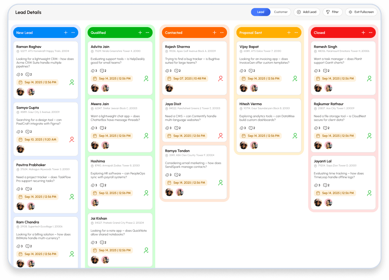
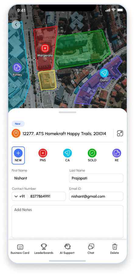
Properties could be represented as interactive pins, territories could be assigned, and reps could work from Map, List or Kanban views.
Geo-verified knocks and proximity-based audit trails created a stronger operational record of field activity.
Make every interaction actionable
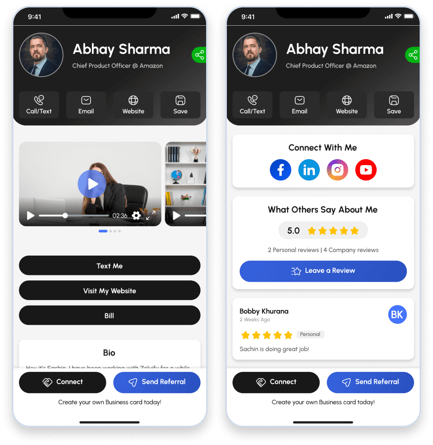
Smart Cards combined profile content, media, reviews and calls to action, while card activity could feed alerts and follow-up workflows.
The card became part of the lead-generation and engagement system rather than a standalone identity product.
Replace manual follow-up with cadences
SMS workflows supported single- and multi-touch sequences, configurable timing and event-driven triggers such as dispositions or card views.
The source architecture references Twilio 10DLC as the messaging layer.
Route appointments using business rules
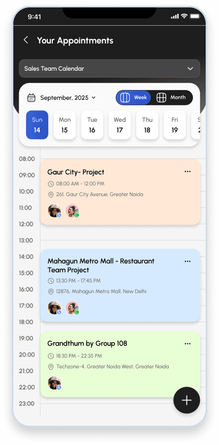
Assignment could support direct routing, round robin, power-ranking and weighted distribution across closer pools.
This moved lead handoff from an ad-hoc process into a configurable operating workflow.
Make performance visible in real time
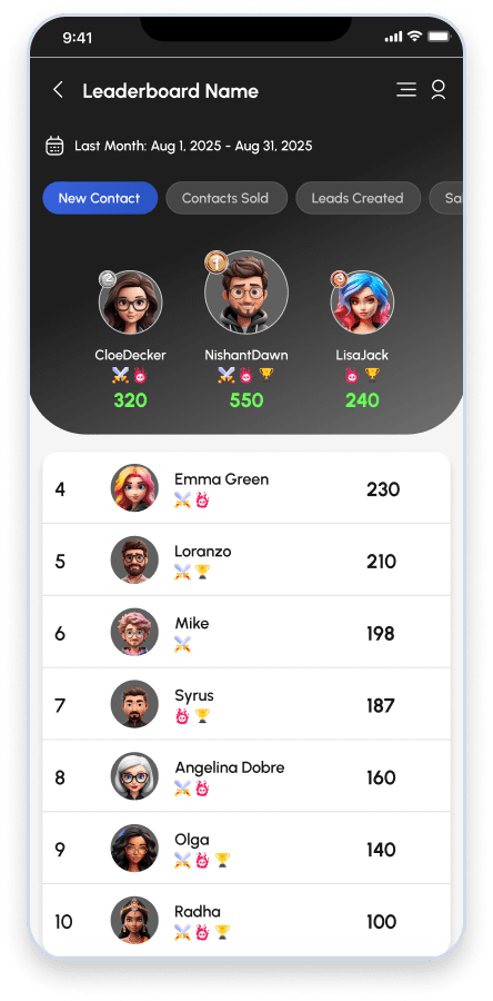
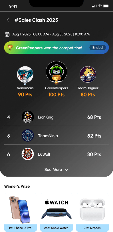
Gamification supported contests, tournaments, prize pools and live leaderboards tied to field activity and outcomes.
WebSocket-based updates were used for real-time leaderboard movement.
Support multiple organizations from one platform
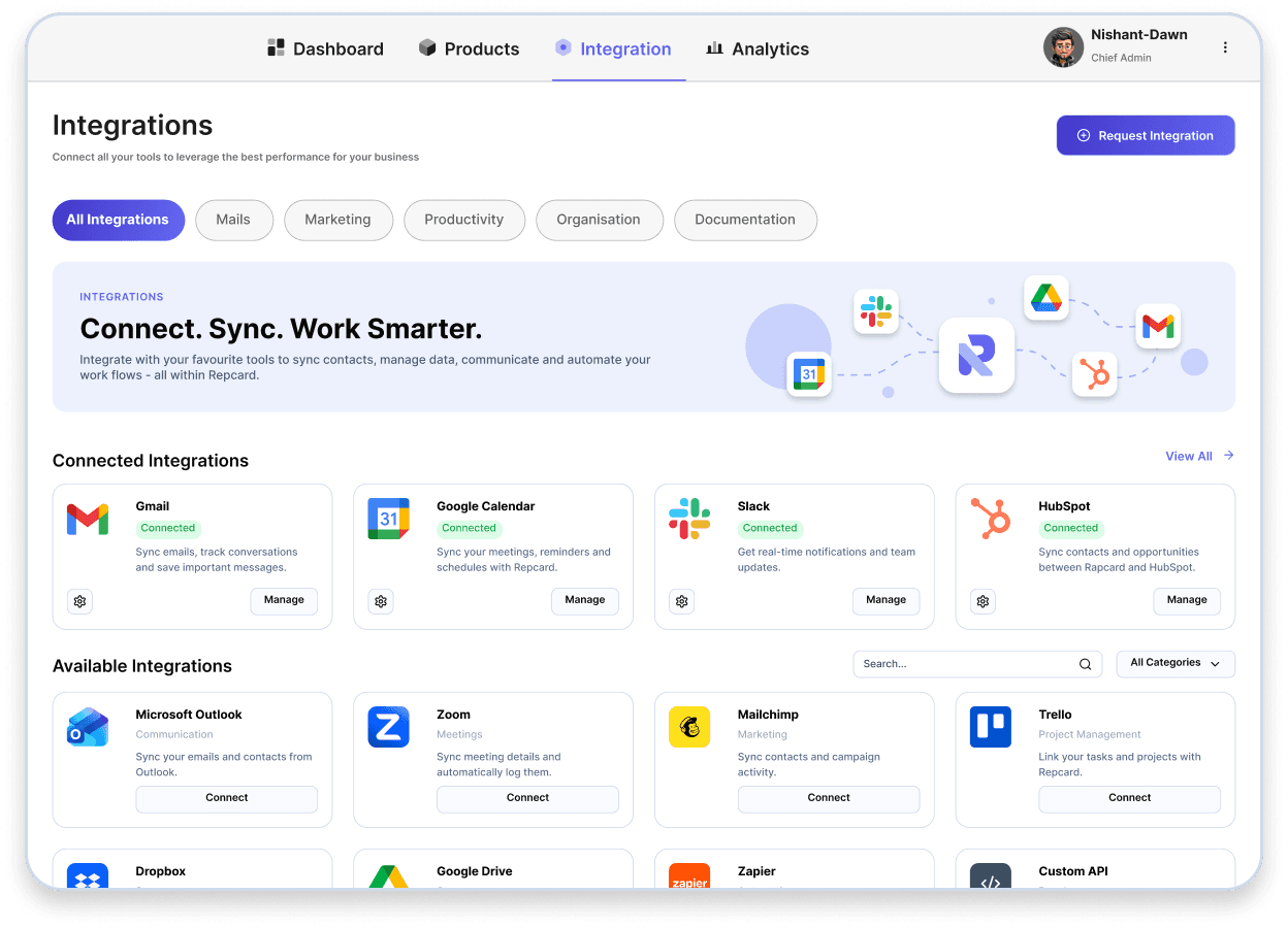
Multi-tenant organization structures, granular permissions, custom fields, integrations, team communication and training workflows supported organizational scale.
The source material references Salesforce, HubSpot, Zapier/webhooks and a training LMS.
Properties · Territories · Leads · Appointments
Partnership model
We operated as an extension of the client's product and technology organization.
The client brought domain expertise, enterprise sales relationships and market direction. Zolvify owned the product and engineering execution described in the engagement.
Client team
- Direct-sales domain expertise
- Enterprise sales and go-to-market
- Strategic relationships
- Market priorities and commercial direction
Zolvify team
- Product roadmapping and UX
- Full-stack architecture and engineering
- Mobile and web development
- Deployment and DevOps
- Ongoing operations
Fractional product leadership
Translate operational friction into product requirements and roadmap decisions.
End-to-end engineering
Design, build and integrate the mobile, web and backend platform.
Continuous operations
Maintain, monitor and evolve the production platform after launch.
Data Handling & Organization Model
Spatial workflows → PostGIS
Property locations, territory boundaries, proximity checks and geo-fencing require spatial data structures and queries. PostgreSQL + PostGIS formed the geospatial data layer.
Turn geography into a working CRM
Properties could be represented as interactive pins, territories could be assigned, and reps could work from Map, List or Kanban views.
Geo-verified knocks and proximity-based audit trails created a stronger operational record of field activity.
Support multiple organizations from one platform
Multi-tenant organization structures, granular permissions, custom fields, integrations, team communication and training workflows supported organizational scale.
Integrations with Salesforce, HubSpot, Zapier/webhooks and a training LMS.
Engineering
The architecture followed the operational problems.
Rather than presenting the stack as a technology checklist, the important engineering story is why these components were needed.
Field representatives cannot always depend on perfect connectivity. The source architecture describes offline-first local caching, background GPS and native push capabilities for the mobile experience.
Property locations, territory boundaries, proximity checks and geo-fencing require spatial data structures and queries. PostgreSQL + PostGIS formed the geospatial data layer.
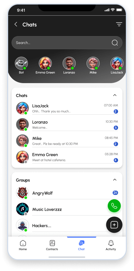
Leaderboards, chat and other real-time experiences require low-latency state updates. Redis and WebSockets were part of the referenced architecture.
AWS S3/CloudFront and application services supported media delivery and cloud infrastructure, while DevOps and ongoing production operations remained part of the engagement.
Source-backed technology stack
| Layer | Technology | What it supports |
|---|---|---|
| Mobile | Swift, Swift-UI, Kotlin; offline-first SQLite cache; background GPS; Map SDK. | Field connectivity → offline-first mobile |
| Web | React / Next.js; enterprise web console; Mapbox GL / Google Maps JavaScript API; Tailwind CSS. | Properties could be represented as interactive pins, territories could be assigned, and reps could work from Map, List or Kanban views. |
| Backend | Node.js / NestJS, Pythong, PHP; REST / GraphQL; WebSockets. | Product roadmapping and UX, full-stack architecture, mobile and web engineering, deployment/DevOps. |
| Data & Geo | PostgreSQL + PostGIS; Redis for cache and queues. | Spatial workflows → PostGIS |
| Communications & Cloud | Twilio 10DLC; AWS S3 / CloudFront; SendGrid; Stripe Billing. | Distributed platform → cloud delivery |
Production ownership
Building the platform was only part of the engagement.
The operational stewardship alongside product engineering.
Release management
Zero-downtime releases and production deployment ownership.
Performance
PostGIS indexing and query tuning for large geospatial datasets.
Reliability
Monitoring and auto-scaling around peak field-sales activity.
Enterprise support
Multi-tier support for the production platform.
Outcomes
What changed
Product transformation
The engagement evolved from a digital business-card utility into a multi-tenant Field Sales Operating System spanning canvassing, CRM, communication, dispatch and gamification.
Tool consolidation
Multiple disconnected field-sales tools toward one integrated platform.
Scale & adoption
162,000+ Active Reps field representatives and millions of doors knocked.
Production reliability
99.9% production uptime.
Why this case matters
This is the kind of engagement Zolvify is built for.
Product thinking
We can help identify the product opportunity behind the initial feature request—not simply implement the first specification.
Complex workflow engineering
We can translate field operations, spatial workflows, role-based processes and automation rules into usable software.
Long-term ownership
We can operate beyond launch across engineering, DevOps, releases, maintenance and continuous product evolution.
FAQ
Field Sales Software frequently asked questions
What is a Field Sales Operating System?
A Field Sales Operating System connects the workflows used by distributed sales teams—such as territory management, canvassing, lead management, communication, appointment dispatch and performance management—into one platform.
What is the difference between field sales software and a CRM?
A traditional CRM primarily manages customer and pipeline data. Field sales software can extend that workflow into physical territory, rep activity, geo-verification, field communication and operational dispatch.
Can field sales software support multiple organizations?
Yes. A multi-tenant architecture can separate organizations while supporting shared platform infrastructure, company-to-team hierarchies, role-based permissions and configurable workflows.
Can field sales platforms integrate with existing CRMs?
The source case study references Salesforce, HubSpot, Zapier/webhooks and custom field mapping as integration capabilities.
Why is PostGIS useful for field sales software?
PostGIS adds spatial capabilities to PostgreSQL, making it suitable for property locations, territory boundaries, proximity checks, geo-fencing and other location-driven workflows.
Can Zolvify own both product and engineering?
This case study demonstrates an engagement model combining product roadmapping and UX with full-stack engineering, DevOps, releases and ongoing platform operations.
Have a complex product to build?
Let's turn the operational problem into the right product.
If you're evaluating a software development partner for a field-sales platform, multi-tenant SaaS product, workflow-heavy application or new digital product, talk to Zolvify about the problem before the implementation.